Cabo
Verde
The Islands |
| |
|
| |
This island, located in the
northwest of the archipelago, features the most
impressive landscape of all of the Cape Verde
Islands.
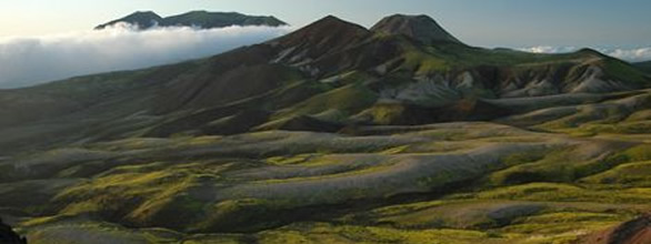
The 779 km² large island with its powerful
massifs like the Tope de Coroa in the southwest
(which reaches up to 1'982 m) and the Pico da
Cruz in the northeast (which reaches up to 1'584
m) is characterized by extremely strong climatic
contrasts. The northern and the eastern parts
of Santo Antão experience often strong
precipitation, especially during the summer months.
This provides the landscape with an luscious,
tropical vegetation while the southern and western
sections are characterized by dryness and a desert-like
moon landscape. |
| |
 |
| |
The island is separated into
3 administrative districts. The largest of them
is the district of Porto Novo. The district of
Ribeira Grande consists of the northern part of
the island. Belonging to this area is the picturesque
fishing town of Ponta do Sol.
The district of Paùl and its administrative
site of Vila das Pombas is located in the east.
Well-known is the valley of Paùl, based
on its rich vegetation and its ideal landscape.
Despite water and vegetation, Santo Antão
is still one of the poorest islands belonging
to the Cape Verde Islands. The people here are,
on the one hand, very earnest and, on the other
hand, still very buoyant despite their social
situation.
Santo Antão has developed in the past few
years more and more into an admired travel destination
for botanists and geologists as well as for lovers
of nature, mountain hikers and mountain bikers.
The brittle charm and the breathtaking landscape
put a spell on many a visitor. |
|
|
 |
|